A tropical wave moving into the Caribbean early this week may strengthen into a named storm, posing potential risks to parts of the U.S. and Caribbean as conditions grow more favourable for development.
A tropical wave is showing signs of potential development and could strengthen into a tropical storm over the Caribbean early this week, AccuWeather meteorologists warn. Confidence is increasing that parts of the Caribbean, and maybe even portions of the southeastern United States may experience direct impacts.
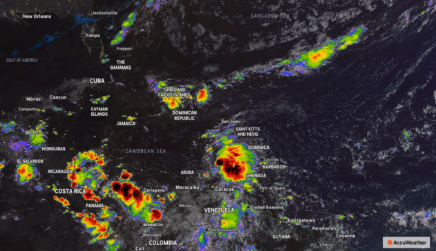
The tropical wave has tracked westward across the Atlantic over the past week, and there are increasing signs that the system could organize into a named tropical storm when it moves into the Caribbean early this week. Tropical waves originate from the Indian Ocean or Africa and travel westward between 10 and 20 mph. On average, from one in three and one in five develop into named tropical storms.
“We are forecasting a high risk of tropical development for the wave moving through the Atlantic’s main development region,” said AccuWeather Lead Hurricane Expert Alex DaSilva. “As it reaches the warm waters of the Caribbean early this week, low wind shear in the southern half of the Caribbean may allow it to quickly become a tropical storm.”
The next tropical storm will be named Melissa.
The wave will bring rain, thunderstorms and gusty winds to some of the Leeward Islands this week. Rough seas are expected as the wave advances across the Caribbean.
“People across the Caribbean should closely monitor forecast updates as the situation could escalate quickly,” DaSilva advised.
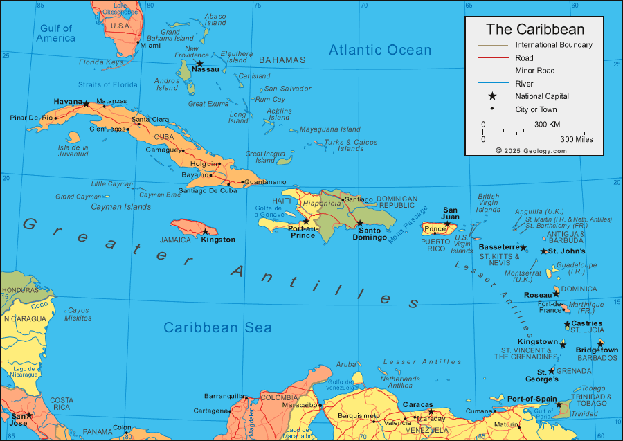
Where might a budding Caribbean tropical storm track?
Multiple scenarios remain in play as the tropical wave begins strengthening.
In the coming days, the west-to-east jet stream pattern will expand and strengthen over much of the contiguous U.S. This acts as a barrier against tropical storms and hurricanes from traveling northward very much in the Gulf and along the U.S. Atlantic coast.
There will be multiple dips in the jet stream that could act to scoop up any budding tropical storm in the Caribbean. This, and the storms strength, would heavily influence the storm’s eventual path.
A stronger storm is more likely to be pulled northward by mid-week, nearing Cuba and Hispanolia. Such a scenario is likely to also lead to the storm stalling near the islands, dumping an immense amount of tropical rainfall on the islands.
A relatively weaker storm is more likely to keep moving northwest across the Caribbean throughout the week. In the latter scenario, strengthening is likely to only be delayed. This would lead to a tropical storm or hurricane in the warm waters of the western Caribbean.
Historically, tropical systems that reach the western Caribbean in October are more likely to be steered away from places like Texas and Louisiana. But the eastern United States, and Florida in particular, can still be impacted by intense storms.
“While I think that the chances of a direct U.S. hit from this storm are low right now, it’s still on the table should the tropical system make it into the western Atlantic,” warned DaSilva.
This may be one of the last tropical waves of the season. However, tropical storms can still form in warm waters of the Caribbean, Gulf and the southwestern Atlantic by other means through the late fall.
“Less than 12 percent of the Atlantic hurricane season is left, climatologically speaking, but no one should let their guard down,” DaSilva said. “The return of La Niña conditions can lead to atmospheric patterns that are conducive to late-season tropical storm development.”
La Niña conditions were present at the end of the 2024 Atlantic hurricane season.
AccuWeather accurately predicted a continuation of tropical activity into last November, when two tropical storms and one hurricane developed in the Atlantic. With the return of La Niña conditions, atmospheric patterns may again favor late-season development — especially across the Caribbean and western Atlantic.
Hurricane season officially ends on Nov. 30.